
Ficheiro:Pali 2016 NASA track.png
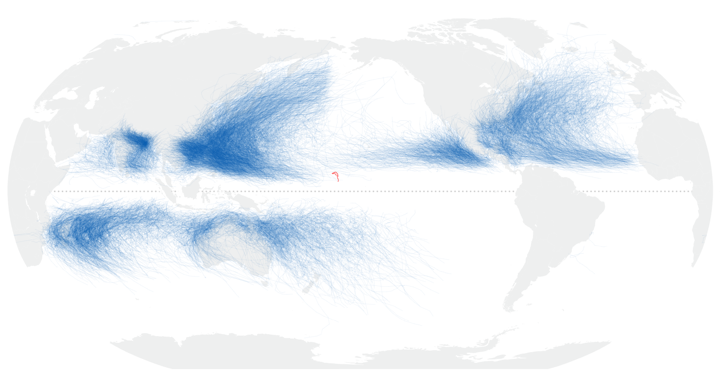
Imagem numa resolução maior (1 482 × 800 píxeis, tamanho: 575 kB, tipo MIME: image/png)
|
|
Esta imagem provém do Wikimedia Commons, um acervo de conteúdo livre da Wikimedia Foundation que pode ser utilizado por outros projetos.
|
Descrição do ficheiro
| Descrição |
English: On January 11, 2016, tropical storm Pali strengthened to a hurricane, becoming the earliest hurricane ever recorded over the Central Pacific Basin in a calendar year.
At 11:30 a.m. local time (22:30 Universal Time) on January 11, the Moderate Resolution Imaging Spectroradiometer (MODIS) on NASA’s Terra satellite captured this view of the storm spinning over the Central Pacific. The image shows that Pali had developed a clear eye, as well as pronounced cirrus banding along much of the storm’s perimeter. Using observations made shortly after this image was acquired, meteorologists classified the storm as a category-1 hurricane, with maximum sustained winds of 140 kilometers (90 miles) per hour. Its location far from Hawaii—about 2,300 kilometers (1,400 miles) to the southwest—meant that Pali’s main effect was to churn up higher-than-usual surf. The cyclone peaked on January 12 as a category-2 storm, then weakened back to category 1 the following day. View an image of the storm on January 13 here. Pali became a hurricane 19 days earlier than the previous record holder, Hurricane Ekeka of 1992. The Central Pacific Hurricane Center noted that Pali provided “yet another record to stack on the ever-growing pile of recent records due in large part to the ongoing strong El Nino.” Also notable is Pali’s location. The map above shows the path of Pali from January 7 to 12, 2016, in context with all global storm tracks in NOAA’s record from 1842 through 2015. Historically, not many storms have ventured so close to the equator so far out in the middle of the basin. Pali’s track appears relatively erratic and loopy. That’s because the storm is situated within a zone of low pressure, blocked to the north by a belt of high atmospheric pressure and winds blowing from the east, and blocked to the south near the equator by strong winds blowing from the west. Weather Underground blogger Lee Grenci speculated that Pali could cross the equator, which would be another first in the history of recorded tropical cyclones. Cyclones don’t usually form close to the equator because the Coriolis effect is usually too weak here to induce much spin. |
| Data | |
| Origem | https://earthobservatory.nasa.gov/NaturalHazards/view.php?id=87314 |
| Autor | NASA image (top) by Jeff Schmaltz, LANCE/EOSDIS Rapid Response. NASA Earth Observatory map (bottom) by Joshua Stevens, using data from NOAA and Unisys Weather. Caption by Kathryn Hansen. |
| Outras versões |
|
.jpg)
Licenciamento
| Este ficheiro está no domínio público nos Estados Unidos porque foi criado exclusivamente pela NASA. As orientações sobre o direito de autor da NASA são que «as obras da NASA não têm os direitos de autor protegidos salvo indicação em contrário». Veja Template:PD-USGov, as orientações sobre o direito de autor da NASA ou as normas de uso de imagens do Laboratório de Propulsão a Jato (Jet Propulsion Lab, JPL). | ||
 |
Avisos:
|
Histórico do ficheiro
Clique uma data e hora para ver o ficheiro tal como ele se encontrava nessa altura.
| Data e hora | Miniatura | Dimensões | Utilizador | Comentário | |
|---|---|---|---|---|---|
| atual | 01h10min de 23 de maio de 2018 | | 1 482 × 800 (575 kB) | Nino Marakot | User created page with UploadWizard |
Utilização local do ficheiro
A seguinte página usa este ficheiro:
Utilização global do ficheiro
As seguintes wikis usam este ficheiro:
- en.wikipedia.org
- uk.wikipedia.org