
Ficheiro:Reelfoot Rift diagram from USGS en.svg

Dimensões desta antevisão em PNG do ficheiro SVG: 426 × 287 píxeis Outras resoluções: 320 × 216 píxeis | 640 × 431 píxeis | 1 024 × 690 píxeis | 1 280 × 862 píxeis | 2 560 × 1 725 píxeis.
Imagem numa resolução maior (ficheiro SVG, de 426 × 287 píxeis, tamanho: 606 kB)
|
|
Esta imagem provém do Wikimedia Commons, um acervo de conteúdo livre da Wikimedia Foundation que pode ser utilizado por outros projetos.
|
Descrição do ficheiro
| Descrição |
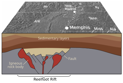
English: Geology of the Reelfoot Rift. From the source: "Geologic structures related to earthquakes in the central Mississippi Valley region have been deeply buried over hundreds of millions of years by thick layers of sediment. Geophysical studies have revealed a major buried northeast-trending feature known as the Reelfoot Rift (here shown in cross section), which formed more than 500 million years ago when powerful geologic forces began to pull the Earth's crust apart. Most quakes in the central Mississippi Valley appear to be related to the major faults and large bodies of igneous rock within the rift." Thomas G. Hildenbrand,Victoria E. Langenheim, Eugene Schweig, Peter H. Stauffer, and James W. Hendley II (USGS) |
| Data | Published in 1996 |
| Origem | "Uncovering Hidden Hazards in the Mississippi Valley" - USGS Fact Sheet, 1996, webpage archived from the original (dead link). Source is now live at this link as of 2021. |
| Autor | USGS |
| Outras versões |
  |
Licenciamento
Esta imagem está no domínio público porque ela contém materiais originalmente provenientes do Serviço Geológico dos Estados Unidos, uma agência do Departamento do Interior dos Estados Unidos. Para mais informações, veja a política oficial da USGS em relação a direitos autorais
|
Histórico do ficheiro
Clique uma data e hora para ver o ficheiro tal como ele se encontrava nessa altura.
| Data e hora | Miniatura | Dimensões | Utilizador | Comentário | |
|---|---|---|---|---|---|
| atual | 05h26min de 15 de janeiro de 2010 | | 426 × 287 (606 kB) | Kbh3rd | {{Information |Description={{en|1=Geology of the Reelfoot Rift. From the source: "Geologic structures related to earthquakes in the central Mississippi Valley region have been deeply buried over hundreds of millions of years by thick layers of sediment. |
Utilização local do ficheiro
A seguinte página usa este ficheiro:
Utilização global do ficheiro
As seguintes wikis usam este ficheiro:
- en.wikipedia.org
- es.wikipedia.org
- eu.wikipedia.org
- fr.wikipedia.org
- he.wikipedia.org
- ja.wikipedia.org
- ko.wikipedia.org
- pl.wikipedia.org