
Ficheiro:Tabula hungariae.jpg

Imagem numa resolução maior (3 236 × 4 609 píxeis, tamanho: 3,27 MB, tipo MIME: image/jpeg)
|
|
Esta imagem provém do Wikimedia Commons, um acervo de conteúdo livre da Wikimedia Foundation que pode ser utilizado por outros projetos.
|
Descrição do ficheiro
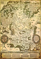
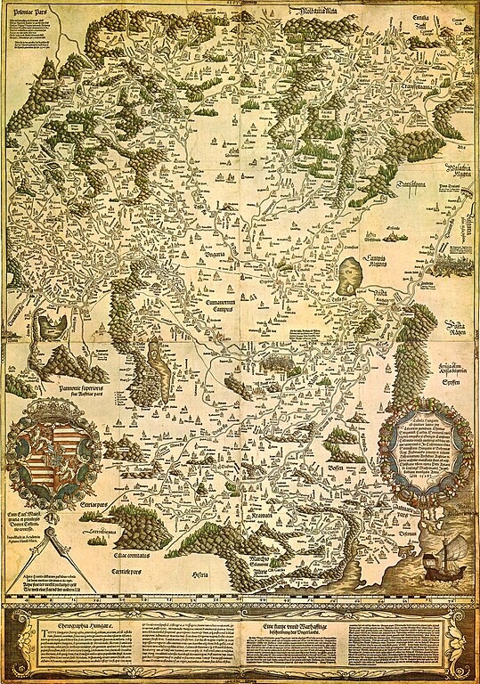
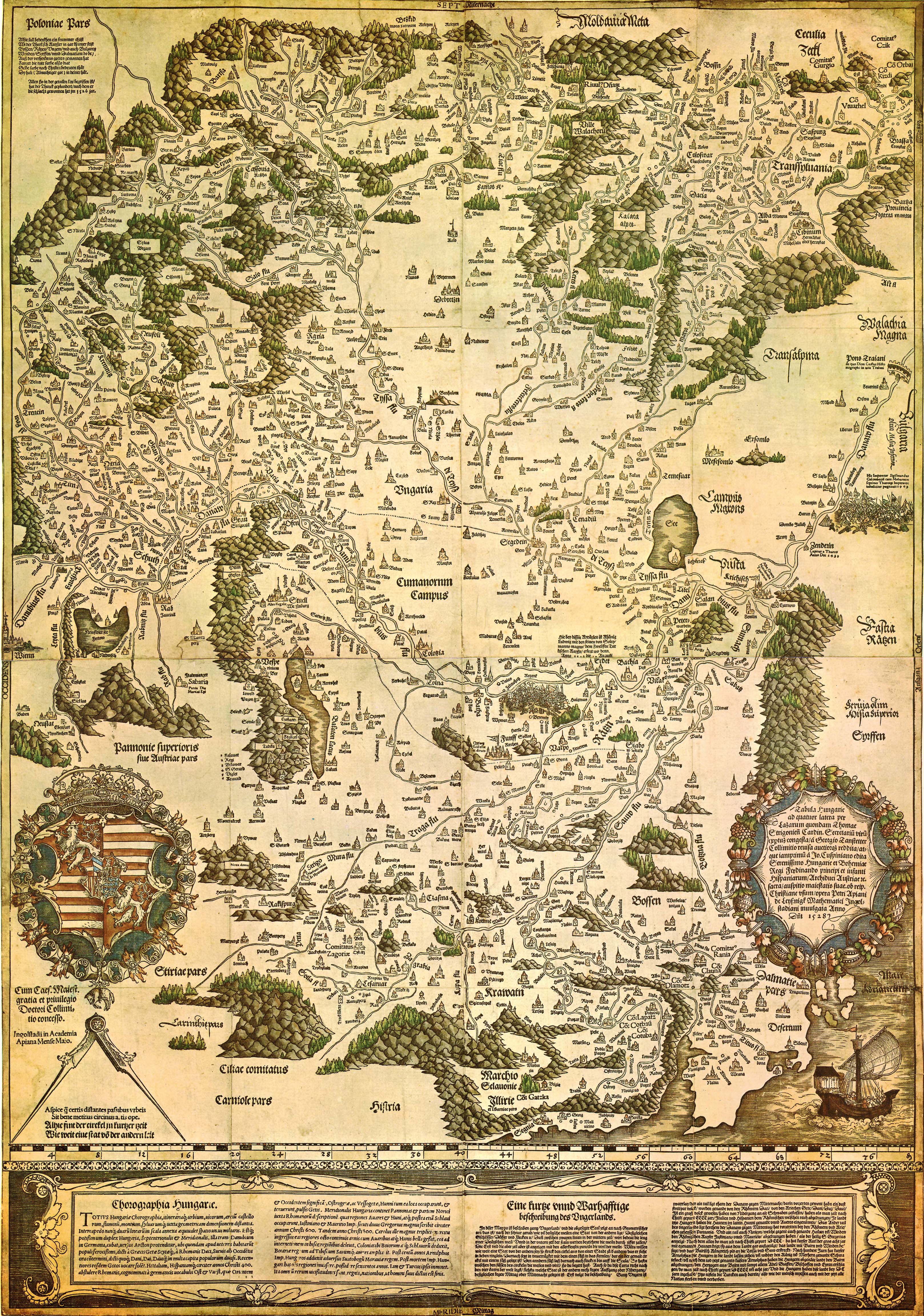
| Tabula Hungariae
|
||
|---|---|---|
| Autor |
Lázár deák (Lazarus secretarius) |
 |
| Título |
latim: Tabula Hungarie ad quatuor latera Tabula Hungariae |
|
| Impressão | ||
| Tipo de objecto |
mapa antigo |
|
| Descrição |
Magyar: A Tabula Hungariae vagy Lázár térképe Magyarország első nyomtatott térképe, amelyet a feltehetően a magyar Lázár deák készített Српски / srpski: Lazarusova karta Ugarske iz 1528. godine na kojoj je na mestu današnjeg Novog Sada ubeleženo naselje Bistritz (Bistrica) |
|
| Data | entre 1526 e 1528 | |
| Data de publicação |
1528 |
|
| Coleção | ||
| Referências | ||
| Arquivo de autoridade | ||
| Fonte/Fotógrafo | http://lazarus.elte.hu/hun/maps/lazar150.jpg | |
| Outras versões |
|
|


Licenciamento
|
Esta obra está no domínio público no seu país de origem e noutros países e áreas onde o período de proteção dos direitos de autor é igual ou inferior à vida do autor mais 100 anos. Esta obra está no domínio público nos Estados Unidos porque foi publicada (ou registada no U.S. Copyright Office) antes de 1 de janeiro de 1929. | |
| Este ficheiro foi considerado livre de restrições conhecidas devidas a direitos de autor, incluindo todos os direitos conexos. | |
Histórico do ficheiro
Clique uma data e hora para ver o ficheiro tal como ele se encontrava nessa altura.
| Data e hora | Miniatura | Dimensões | Utilizador | Comentário | |
|---|---|---|---|---|---|
| atual | 23h02min de 29 de agosto de 2009 | | 3 236 × 4 609 (3,27 MB) | Qorilla | {{Information |Description={{en|1=Tabula Hungariae, first printed map of Hungary}} |Source=Hungarian Wikipedia |Author=Lázár deák (Lazarus secretarius) |Date=somewhere between 1526-1528 |Permission= |other_versions= }} Category:Old maps of Hungary |
Utilização local do ficheiro
A seguinte página usa este ficheiro:
Utilização global do ficheiro
As seguintes wikis usam este ficheiro:
- ar.wikipedia.org
- bn.wikipedia.org
- bs.wikipedia.org
- ca.wikipedia.org
- de.wikipedia.org
- el.wikipedia.org
- en.wikipedia.org
- Pannonia
- Treaty of Trianon
- Hungarian Revolution of 1956
- Austro-Hungarian Compromise of 1867
- Military Frontier
- Hungarian nobility
- History of Hungary before the Hungarian conquest
- Hungarian prehistory
- Kingdom of Hungary (1526–1867)
- History of geography
- Georg Tannstetter
- Upper Hungary
- History of the Jews in Hungary
- Music history of Hungary
- Bistrica, Novi Sad
- Lands of the Crown of Saint Stephen
- History of Transylvania
- Template:History of Hungary
- Hungarian People's Republic
- Principality of Transylvania (1570–1711)
- Military history of Hungary
- First Hungarian Republic
- Ottoman Hungary
- Hungary between the World Wars
- Principality of Hungary
- Hungarian Revolution of 1848
- Rákóczi's War of Independence
- Eastern Hungarian Kingdom
- Kingdom of Hungary (1920–1946)
- Hungary in World War I
- Second Hungarian Republic
Ver mais utilizações globais deste ficheiro.