
Ficheiro:The Man in the High Castle Plausible World Map.png
Dimensões desta antevisão: 800 × 579 píxeis. Outras resoluções: 320 × 232 píxeis | 640 × 463 píxeis | 1 024 × 741 píxeis | 1 280 × 926 píxeis | 1 577 × 1 141 píxeis.
Imagem numa resolução maior (1 577 × 1 141 píxeis, tamanho: 400 kB, tipo MIME: image/png)
|
|
Esta imagem provém do Wikimedia Commons, um acervo de conteúdo livre da Wikimedia Foundation que pode ser utilizado por outros projetos.
|

|
Este mapa, assim como outros mapas fictícios, é fictício ou muito incorreto (ou seja, devido ao anacronismo) para ser usado em contextos da vida real (contemporânea ou histórica). Pode ter alguns elementos visuais semelhantes aos mapas oficiais, como cores ou certos recursos de layout, mas NÃO são oficiais e não têm nenhum reconhecimento oficial. |
[[Category:]]
Descrição do ficheiro
| Descrição |
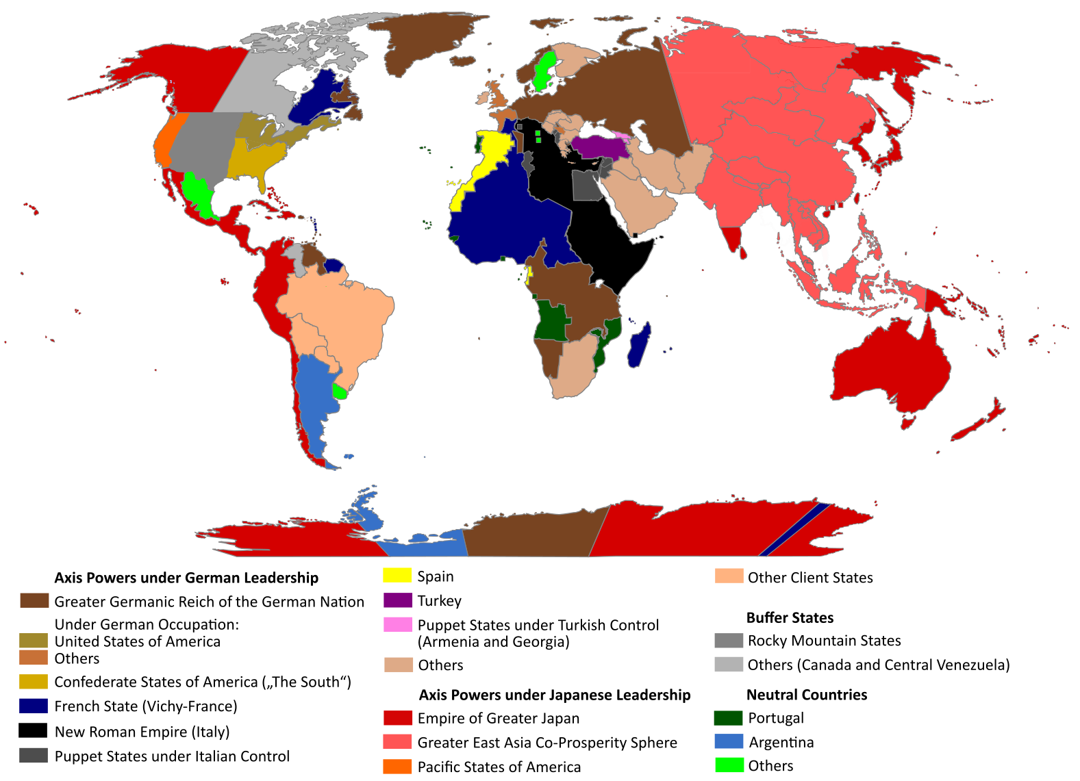
English: "The Man in the High Castle" is an alternate history novel by Philip K. Dick. It is set in a world in which the Axis powers have won World War II. This map is inspired by Dick's story and shows a plausible division of the world between Nazi Germany (dark brown), Imperial Japan (dark red) and their respective allies. However, the map is much more precise than the book describes.
https://web.archive.org/web/20191202005150/http://www.high-castle-world-map.com:80/ |
| Data | |
| Origem | Obra do próprio |
| Autor | RobintheHighCastle |
| Permissão (Reutilizar este ficheiro) |
Licenciamento
Eu, titular dos direitos de autor desta obra, publico-a com a seguinte licença:
A utilização deste ficheiro é regulada nos termos da licença Creative Commons Atribuição-CompartilhaIgual 4.0 Internacional.
- Pode:
- partilhar – copiar, distribuir e transmitir a obra
- recombinar – criar obras derivadas
- De acordo com as seguintes condições:
- atribuição – Tem de fazer a devida atribuição da autoria, fornecer uma hiperligação para a licença e indicar se foram feitas alterações. Pode fazê-lo de qualquer forma razoável, mas não de forma a sugerir que o licenciador o apoia ou subscreve o seu uso da obra.
- partilha nos termos da mesma licença – Se remisturar, transformar ou ampliar o conteúdo, tem de distribuir as suas contribuições com a mesma licença ou uma licença compatível com a original.
Histórico do ficheiro
Clique uma data e hora para ver o ficheiro tal como ele se encontrava nessa altura.
| Data e hora | Miniatura | Dimensões | Utilizador | Comentário | |
|---|---|---|---|---|---|
| atual | 14h55min de 29 de outubro de 2021 | | 1 577 × 1 141 (400 kB) | Saltner67 | Added the portoguese colonies Cabinda and Ajuda since they would still have existed in this world. |
| 08h05min de 20 de junho de 2021 |  | 1 613 × 1 143 (417 kB) | Gernsback67 | Changed "Greater Asian Co-Prosperity Sphere" in "Greater East Asia Co-Prosperity Sphere", which is correct. | |
| 15h30min de 16 de outubro de 2020 |  | 1 611 × 1 138 (418 kB) | Saltner67 | Restored the latest version. Please do not revert any changes, which have been made to this file so far, without any communication with the author of the map. All changes made here have been initialized by the author and are a result of the same process which has led to the creation of the map in the first place. | |
| 08h25min de 16 de outubro de 2020 |  | 1 621 × 1 137 (392 kB) | Gooduserdude | RV Original research: this image is based on a source and should not be altered | |
| 14h15min de 29 de março de 2020 |  | 1 611 × 1 138 (418 kB) | Saltner67 | Improved the accuracy of borders of Mongolia and Manchukuo. | |
| 15h58min de 27 de março de 2020 |  | 1 607 × 1 138 (418 kB) | Saltner67 | Enlarged Manchukuo and added the puppet states of Yakutia and Krasnoyarsk/Irkutsk after more research on Kantokuen. | |
| 19h07min de 12 de março de 2020 |  | 1 612 × 1 143 (411 kB) | Saltner67 | Moved the Swiss Canton of Valais from Germany to Italy, as has been prepared in the plans for Operation Tannenbaum. | |
| 18h57min de 8 de fevereiro de 2020 |  | 1 605 × 1 139 (411 kB) | Saltner67 | Reinserted the territories of Tunisia,Greece, Crete and Cyprus after research on the Italian plannings and Greece in WWII. | |
| 13h21min de 21 de novembro de 2019 |  | 1 611 × 1 133 (409 kB) | Gernsback67 | Enlarged Mongolia again after more research on pan-mongolism. | |
| 15h13min de 21 de setembro de 2019 |  | 1 610 × 1 137 (408 kB) | Saltner67 | unified Mongolia, enlarged Manchukuo and Thailand, re-inserted the real-life borders of Laos and Vietnam after research on Demchugdongrub, Kantokuen, Thailand and Indochina in WWII |
Utilização local do ficheiro
A seguinte página usa este ficheiro:
Utilização global do ficheiro
As seguintes wikis usam este ficheiro:
- ar.wikipedia.org
- cs.wikipedia.org
- da.wikipedia.org
- de.wikipedia.org
- en.wikipedia.org
- en.wikiquote.org
- es.wikipedia.org
- gl.wikipedia.org
- he.wikipedia.org
- hu.wikipedia.org
- it.wikipedia.org
- ja.wikipedia.org
- ko.wikipedia.org
- lt.wikipedia.org
- nl.wikipedia.org
- pl.wikipedia.org
- ro.wikipedia.org
- ru.wikipedia.org
- th.wikipedia.org
- uk.wikipedia.org
- zh-classical.wikipedia.org
- zh.wikipedia.org