
Ficheiro:USGS Kīlauea image-409.jpg

Dimensões desta antevisão: 776 × 600 píxeis. Outras resoluções: 311 × 240 píxeis | 621 × 480 píxeis | 994 × 768 píxeis | 1 280 × 989 píxeis | 2 560 × 1 978 píxeis | 3 300 × 2 550 píxeis.
Imagem numa resolução maior (3 300 × 2 550 píxeis, tamanho: 3,98 MB, tipo MIME: image/jpeg)
|
|
Esta imagem provém do Wikimedia Commons, um acervo de conteúdo livre da Wikimedia Foundation que pode ser utilizado por outros projetos.
|
Descrição do ficheiro
| Descrição |
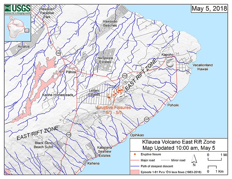
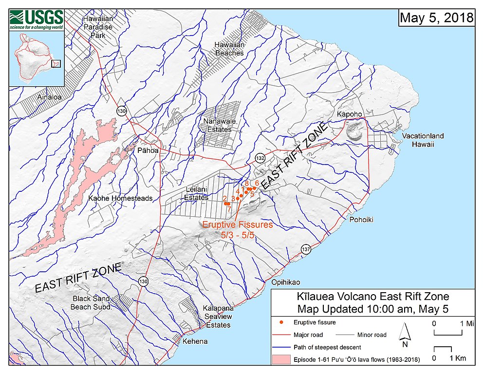
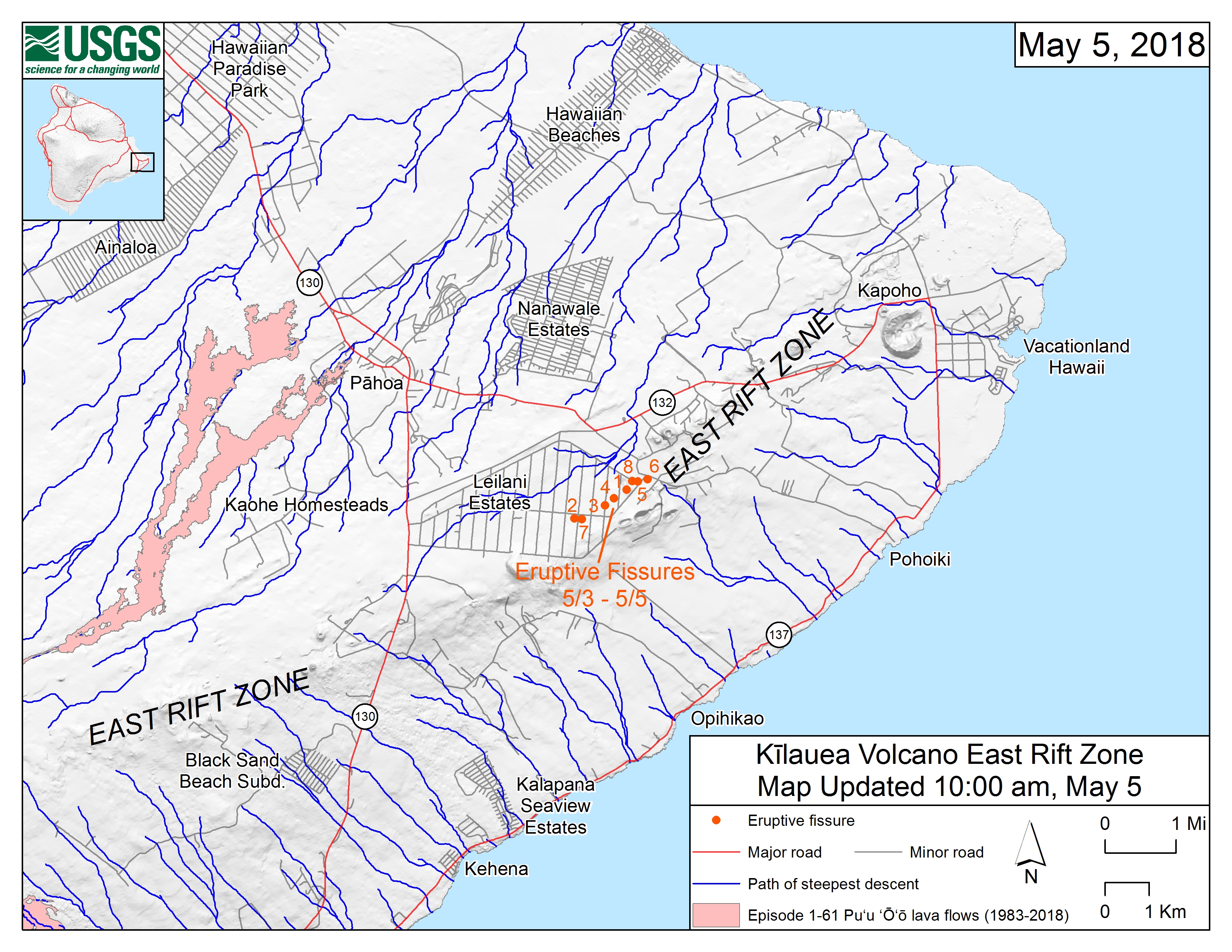
English: Map of the locations of eruptive fissures and the steepest descent paths in area of eruptive fissures, Kīlauea East Rift Zone; 10:00 a.m. HST (May 5, 2018) This map shows the locations of eruptive fissures in the order that they occurred in the Leilani Estates Subdivision as of 10:00 a.m. HST (May 5, 2018). The blue lines are paths of steepest descent that identify likely paths of a lava flow, if and when lava moves downhill from an erupting vent. The paths of steepest-descent were calculated from a 1983 digital elevation model (DEM) of the Island of Hawai‘i, created from digitized contours. Steepest-descent path analysis is based on the assumption that the DEM perfectly represents the earth's surface. DEMs, however, are not perfect, so the blue lines on this map can be used to infer only approximate lava-flow paths. The base shaded-relief map was made from the 1983 10-m (DEM). For additional explanation of steepest descent paths, see http://pubs.usgs.gov/of/2007/1264. For calculation details, ESRI shapefiles, and KMZ versions of steepest descent paths, see https://www.sciencebase.gov/catalog/item/57fd072ee4b0824b2d130eb5. |
| Data | |
| Origem | https://volcanoes.usgs.gov/observatories/hvo/maps_uploads/image-409.jpg |
| Autor | United States Geological Survey |
Licenciamento
Esta imagem está no domínio público porque ela contém materiais originalmente provenientes do Serviço Geológico dos Estados Unidos, uma agência do Departamento do Interior dos Estados Unidos. Para mais informações, veja a política oficial da USGS em relação a direitos autorais
|
Histórico do ficheiro
Clique uma data e hora para ver o ficheiro tal como ele se encontrava nessa altura.
| Data e hora | Miniatura | Dimensões | Utilizador | Comentário | |
|---|---|---|---|---|---|
| atual | 16h44min de 6 de maio de 2018 | | 3 300 × 2 550 (3,98 MB) | ThT | User created page with UploadWizard |
Utilização local do ficheiro
A seguinte página usa este ficheiro:
Utilização global do ficheiro
As seguintes wikis usam este ficheiro:
- ca.wikipedia.org
- de.wikipedia.org
- en.wikipedia.org
- ja.wikipedia.org