
Ficheiro:Aksai Chin Sino-Indian border map.png

Imagem numa resolução maior (624 × 872 píxeis, tamanho: 102 kB, tipo MIME: image/png)
|
|
Esta imagem provém do Wikimedia Commons, um acervo de conteúdo livre da Wikimedia Foundation que pode ser utilizado por outros projetos.
|
Descrição do ficheiro

|
File:Aksai Chin Sino-Indian border map.svg é uma versão vetorial deste ficheiro. Ela deve ser usada em vez desta imagem em formato raster, se não for de qualidade inferior.
File:Aksai Chin Sino-Indian border map.png → File:Aksai Chin Sino-Indian border map.svg
Para mais informações, consulte Ajuda:SVG. |
 |
| Descrição |
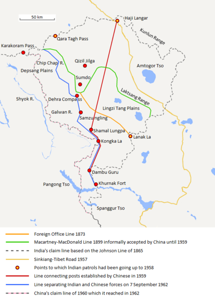
English: The map shows the Indian and Chinese claims of the border in the Aksai Chin region, the Macartney-MacDonald line, the Foreign Office Line, as well as the progress of Chinese forces as they occupied areas during the Sino-Indian War. |
| Data | |
| Origem | Obra do próprio |
| Autor | The Discoverer |
The Macartney-MacDonald line is described as follows: "From the Karakoram Pass the crests of the range run nearly east for about half a degree, and then turn south to a little below the 35th parallel.. Rounding... the source of the Karakash, the line of hills to be followed runs north-east to a point east of Kizil Jilga and from there, in a south-easterly direction, follows the Lak Tsung (Lokzhung) Range until that meets a spur.. which has hitherto been shown on our maps as the eastern boundary of Ladakh.[1]
The Macartney-MacDonald line was never accepted by China, although they informally indicated acceptance on certain occasions:
- Woodman, Dorothy (1969) Himalayan Frontiers: A Political Review of British, Chinese, Indian, and Russian Rivalries, Praeger, p. 102 "The proposed boundary seems never to have been considered in the same form again until Alastair Lamb revived it in 1964."
- Lamb, Alastair (1965). "Treaties, Maps and the Western Sector of the Sino-Indian Boundary Dispute". The Australian Year Book of International Law. "Unfortunately, the Chinese never replied formally to the note, though they indicated informally on a number of occasions their agreement as to its boundary alignment."
In 1959, Chou confirmed the new Chinese claim line to Nehru.
References: [2] cópia arquivada at the Wayback Machine [3] [4] [5] [6] Map on last page cópia arquivada at the Wayback Machine [7]
![[2]](http://cpasindia.org/images/sino-india1.jpg)
![[3]](http://www.frontline.in/static/html/fl2018/images/20030912002104801.jpg)
![[4]](http://www.frontline.in/static/html/fl2018/images/20030912002104802.jpg)
![[5]](http://www.frontline.in/static/html/fl2320/images/20061020001608505.jpg)
![[6]](http://www.indiandefencereview.com/wp-content/uploads/2013/06/Aksai-Chin-GOI-Map.jpg)
Licenciamento
- Pode:
- partilhar – copiar, distribuir e transmitir a obra
- recombinar – criar obras derivadas
- De acordo com as seguintes condições:
- atribuição – Tem de fazer a devida atribuição da autoria, fornecer uma hiperligação para a licença e indicar se foram feitas alterações. Pode fazê-lo de qualquer forma razoável, mas não de forma a sugerir que o licenciador o apoia ou subscreve o seu uso da obra.
- partilha nos termos da mesma licença – Se remisturar, transformar ou ampliar o conteúdo, tem de distribuir as suas contribuições com a mesma licença ou uma licença compatível com a original.
Histórico do ficheiro
Clique uma data e hora para ver o ficheiro tal como ele se encontrava nessa altura.
| Data e hora | Miniatura | Dimensões | Utilizador | Comentário | |
|---|---|---|---|---|---|
| atual | 20h06min de 7 de setembro de 2020 | | 624 × 872 (102 kB) | The Discoverer | Removed Tibet-Sinkiang boundary, added label for Amtogor Tso. |
| 02h51min de 9 de junho de 2020 |  | 624 × 872 (102 kB) | MarkH21 | Intended change from the last edit (i.e. latest version with "informally" per references in talk discussion) | |
| 02h29min de 9 de junho de 2020 |  | 624 × 872 (101 kB) | MarkH21 | Reverted to version as of 00:21, 7 February 2018 (UTC) This was the previous version; the addition of “accepted by China until 1959” was the contested change, not the revert to the original description (the refs are also now dead, but previously said tacit acceptance which isn’t outright acceptance) | |
| 19h37min de 23 de abril de 2018 |  | 624 × 872 (102 kB) | The Discoverer | Reverted to version as of 09:10, 13 December 2017 (UTC) The file of 12 December removes a statement that is supported by the source. As per COM:OVERWRITE, "Controversial or contested changes should be uploaded to a separate filename" | |
| 00h21min de 7 de fevereiro de 2018 |  | 624 × 872 (101 kB) | 樂號 | Reverted to version as of 23:05, 12 December 2017 (UTC) | |
| 09h10min de 13 de dezembro de 2017 |  | 624 × 872 (102 kB) | The Discoverer | Reverted to version as of 11:07, 19 February 2017 (UTC) The file of 12 December removes a statement that is supported by the source. As per COM:OVERWRITE, "Controversial or contested changes should be uploaded to a separate filename" | |
| 23h05min de 12 de dezembro de 2017 |  | 624 × 872 (101 kB) | 樂號 | Macartney–MacDonald Line is only proposed by Britain No official accept made by China | |
| 11h07min de 19 de fevereiro de 2017 |  | 624 × 872 (102 kB) | The Discoverer | Added Karakoram Pass and Kunlun Range | |
| 15h26min de 1 de abril de 2015 |  | 624 × 872 (59 kB) | RokerHRO | optipng -o7 -i0 → 40.77% decrease | |
| 15h00min de 2 de outubro de 2014 |  | 624 × 872 (99 kB) | The Discoverer | Uploaded correct file with scale added. |
Utilização local do ficheiro
As seguintes 2 páginas usam este ficheiro:
Utilização global do ficheiro
As seguintes wikis usam este ficheiro:
- ar.wikipedia.org
- ast.wikipedia.org
- as.wikipedia.org
- az.wikipedia.org
- bh.wikipedia.org
- bn.wikipedia.org
- ca.wikipedia.org
- de.wikipedia.org
- en.wikipedia.org
- es.wikipedia.org
- fr.wikipedia.org
- hi.wikipedia.org
- id.wikipedia.org
- it.wikipedia.org
- ja.wikipedia.org
- ka.wikipedia.org
- kn.wikipedia.org
- ko.wikipedia.org
- lv.wikipedia.org
- ml.wikipedia.org
- ms.wikipedia.org
- nl.wikipedia.org
- no.wikipedia.org
- or.wikipedia.org
- pl.wikipedia.org
- ro.wikipedia.org
- ru.wikipedia.org
- ru.wikinews.org
- sr.wikipedia.org
- ta.wikipedia.org
- te.wikipedia.org
- uk.wikipedia.org
- vi.wikipedia.org
Ver mais utilizações globais deste ficheiro.