
Ficheiro:MAP&LIST of the General location of the Japanese POW Laborers’ camps in the Soviet Union and in Outer Mongolia around 1946.pdf

Imagem numa resolução maior (2 550 × 1 650 píxeis, tamanho: 6,89 MB, tipo MIME: application/pdf)
|
|
Esta imagem provém do Wikimedia Commons, um acervo de conteúdo livre da Wikimedia Foundation que pode ser utilizado por outros projetos.
|
Descrição do ficheiro
| Descrição |
English: LEGEND:
NOTE 1. ○Large Circles with heavy outline (numbered in red): Over 20,000 detained. ●Black circles (numbered in blue): Over 10,000. ○White, small circles (numbered in black): Less than 10,000. △Triangles (numbered in Green): Small number. NOTE 2. The above-designated graphic symbols show the principal area of the labor camp location. Created by combining two maps, published by the former Ministry of Health and Welfare and the current Ministry of Labor, Health and Welfare of the Japanese Government: 1)Kôseishô engokyoku [Bureau of Assistance, Ministry of Health and Welfare]. Hikiage to engo sanjûnen no ayumi [Thirty-year progress of the repatriation and assistance]. Kôseishô. 1977. P56. 2)Kôseishô shakai/engokyoku engo gojûnenshi henshû iinkai [Editorial Committee of Fifty-year history of assistance. Bureau of Social/Assistance, Ministry of Health and Welfare]. Engo gojûnenshi [Fifty-year history of assistance]. Gyôsei. 1997. pp524-525. Location names, listed originally in katakana-Japanese, have been transcribed into English using five maps published in the United States, United Kingdom, and USSR. A)Union of Soviet Socialist Republic. Compiled and drawn in the Cartographic Section of the National Geographic Society for the National Geographic Magazine. Grovesnor, Gilbert. Ed. Washington. U.S.A. 1944. B)U.S.S.R.and Adjacent Areas 1:8,000,000. Published by Department of Survey, Ministry of Defense, United Kingdom. British Crown Copyright Reserved Series 5104. U.K. 1964. C)USSR Railways. J.R. Yonge. The Quail Map Company. Exeter. U. K. 1973. D)USSR Railways. J.R. Yonge. The Quail Map Company. Exeter. U.K. 1976. E)Soviet Union. Produced by the Cartographic Division. National Geographic Society. National Geographic Magazine. Grovesnor, Melville B. Ed. Washington. U.S.A. 1976. F)Union of Soviet Socialist Republic. Moscow News Supplement. Main Administration of Geodesy and Cartography under the Council of Minister of the USSR. U.S.S.R. 1979. |
| Data | |
| Origem | Obra do próprio |
| Autor | Sey Nishimura |
Licenciamento
- Pode:
- partilhar – copiar, distribuir e transmitir a obra
- recombinar – criar obras derivadas
- De acordo com as seguintes condições:
- atribuição – Tem de fazer a devida atribuição da autoria, fornecer uma hiperligação para a licença e indicar se foram feitas alterações. Pode fazê-lo de qualquer forma razoável, mas não de forma a sugerir que o licenciador o apoia ou subscreve o seu uso da obra.
- partilha nos termos da mesma licença – Se remisturar, transformar ou ampliar o conteúdo, tem de distribuir as suas contribuições com a mesma licença ou uma licença compatível com a original.
Histórico do ficheiro
Clique uma data e hora para ver o ficheiro tal como ele se encontrava nessa altura.
| Data e hora | Miniatura | Dimensões | Utilizador | Comentário | |
|---|---|---|---|---|---|
| atual | 16h51min de 19 de agosto de 2017 | 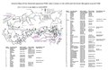 | 2 550 × 1 650 (6,89 MB) | Seynishim | User created page with UploadWizard |
Utilização local do ficheiro
A seguinte página usa este ficheiro:
Utilização global do ficheiro
As seguintes wikis usam este ficheiro:
- az.wikipedia.org
- en.wikipedia.org
- ro.wikipedia.org
- tr.wikipedia.org